Pen Tool
The Pen Tool is used to create polygon-based objects on the map. It allows users to draw custom shapes and corners using left-click points. The Pen Tool is commonly used for creating:
- Restricted Areas
- Traffic Islands
- Parking Lines
- Road Markings
- Gantries

Note
The Pen Tool is not available in Scenery View for editing or creation. Switch to 2D View to create or edit polygon objects.
How to Create an Object Using the Pen Tool
Follow these steps to create an object on the map:
- Right-click on the desired road.
- Use left-clicks to draw the outline of the object.
- Continue placing points until the shape is complete.
- Press Enter to finalize and create the object.
Polygon Properties Panel
When the Pen Tool is selected, the Polygon Properties Panel appears on the RepliMap interface. This panel allows you to configure polygon properties.
Polygon properties panel screenshot
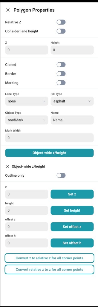
Polygon Properties
| Property | Type | Description |
|---|---|---|
| Relative Z | Toggle | Sets the polygon height (Z value) relative to the ground or lane level instead of using an absolute world height. |
| Consider Lane Height | Toggle | Automatically adjusts the polygon height according to lane elevation. |
| Z | Numeric field | Defines the vertical position of the polygon from the ground. |
| Height | Numeric field | Defines the thickness or vertical size of the polygon. |
| Closed | Toggle | When enabled, the polygon becomes a closed shape by connecting the first and last points. When disabled, the polygon remains open. |
| Border | Toggle | Adds a visible outline or border around the polygon. |
| Marking | Toggle | Enables road marking behaviour on the polygon. |
Type Selection Options
| Option | Type | Description |
|---|---|---|
| Lane Type | Dropdown | Defines the lane category associated with the polygon (e.g., driving lane, sidewalk). |
| Fill Type | Dropdown | Specifies the polygon surface material (e.g., asphalt, grass). |
| Object Type | Dropdown | Defines the object category (e.g., Traffic Island, Roadmark, Gantry). |
| Name | Text field | Assigns a custom name to the polygon object. |
Polygon Object Properties Panel
The Polygon Object Properties Panel functions similarly to the Object Properties Panel.
After creating a polygon object, selecting it opens the Polygon Object Properties Panel on the right side of the editor. This panel allows users to view, modify, and adjust the polygon object properties.
Adding a Gantry Using the Pen Tool
-
Left-click to select the Pen Tool. Right-click on the road to select it.
-
For a single gantry:
- Draw three polygon points where you want to place the gantry.
- Place the first two points at the same position where the gantry starts.
- Place the third point where the gantry ends.
-
For a double gantry:
- Draw two points on one side of the gantry.
- Draw two more points on the other side (the opposite end).
After drawing the polygon, open the Polygon Properties Panel to set values.
Important Note
Object-wide Z / Height is not required for gantry creation and should not be used for gantry objects.