GeoJSON
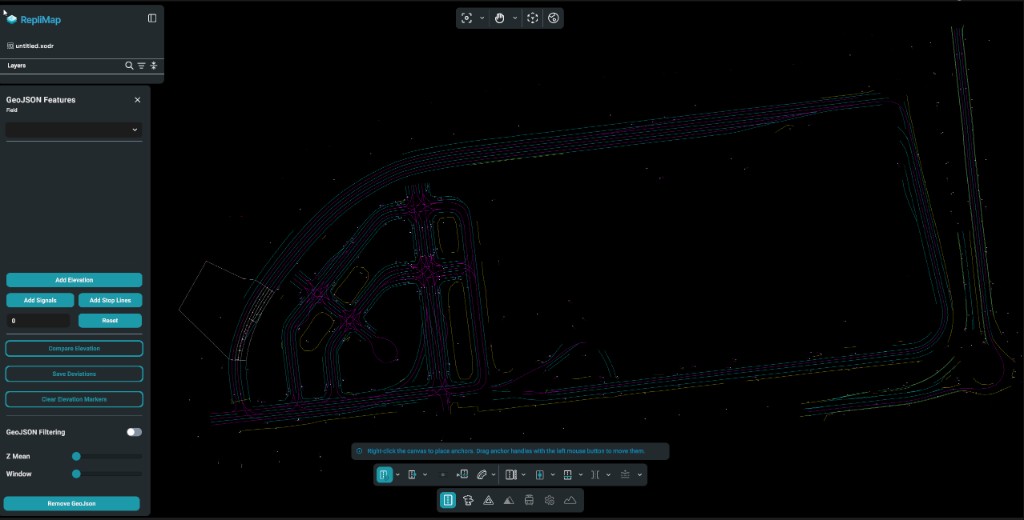
GeoJSON is a common format for vector geodata (points, lines, polygons) with properties. In RepliMap, GeoJSON often appears as reference geometry or imported layers that you align with roads, lanes, and junctions, or merge into your map pipeline.
Typical Uses
- Road centrelines or boundaries from GIS tools or open data.
- Area features (zones, polygons) that constrain or annotate the map.
- Point features (signs, poles, landmarks) as hints for placement or validation.
Coordinate Reference (CRS)
GeoJSON is usually WGS 84 (longitude/latitude). Your project may use a local or projected CRS internally. When importing:
- RepliMap can convert WGS 84 GeoJSON to UTM (after zone detection) or to ENU (using the first GeoJSON coordinate, or the loaded XODR georeference when available).
- If your GeoJSON is already in metre-based coordinates, select the matching CRS option (ENU or UTM) during import.
- Always choose the correct CRS when aligning to an existing map; a wrong CRS causes visible misalignment and editing errors.
- Preserve accuracy near the origin; very large coordinates may need a projected CRS for stable editing.
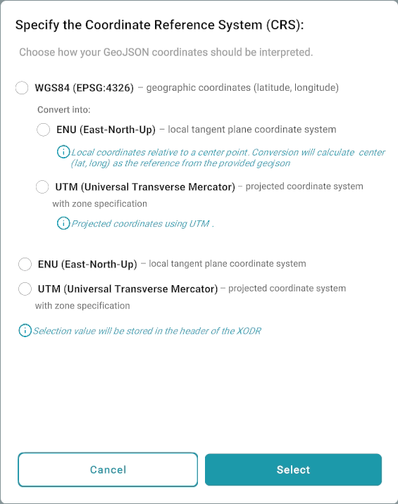
When you import GeoJSON, RepliMap opens Specify the Coordinate Reference System (CRS) so you can choose how coordinates are interpreted.
The dialog offers WGS84 (EPSG:4326) (latitude/longitude) with Convert into: ENU (local tangent plane from a computed centre) or UTM (zone-based projection). You can also pick ENU or UTM at the top level when your GeoJSON is already in metre-based coordinates in that system. The chosen CRS is stored in the XODR header when the map is saved.
CRS dialog screenshot
Properties for Visualization
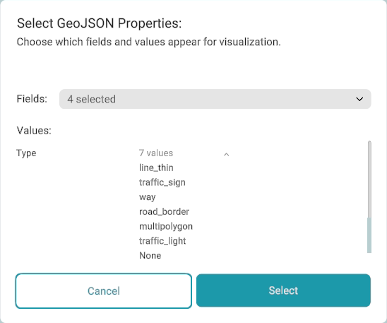
After CRS selection, RepliMap can open Select GeoJSON Properties: so you can choose which fields and values are used for drawing the GeoJSON on the canvas. That choice drives how features are grouped for colouring: for example, if your features use a property key such as type, you can assign a separate colour to each value (way, road_border, traffic_sign, traffic_light, and so on).
Use Fields to choose which property keys control styling. Under Values, RepliMap lists the distinct values for each selected key; only the combinations you include are drawn as separate categories, which keeps complex GeoJSON readable while you align and edit the map.
Keys with more than 30 distinct values are not available for categorical colouring—high-cardinality fields such as id would assign a different colour to almost every feature, which is not useful for visual grouping.
GeoJSON properties dialog screenshot
GeoJSON Panel
After GeoJSON is loaded, the GeoJSON sidebar keeps reference data under control while you edit: feature styling and visibility, elevation workflows, signals, stop lines, filtering, and reset actions. The panel follows this broad layout:
- GeoJSON features — display and style features by property.
- Add Elevation — add or compare elevation and manage deviations.
- Add Signals — import traffic signals from GeoJSON where supported.
- Add Stop Lines — add stop lines from GeoJSON where the dataset supports it.
- Reset — clear numeric offsets or related settings.
GeoJSON panel screenshot
GeoJSON Features
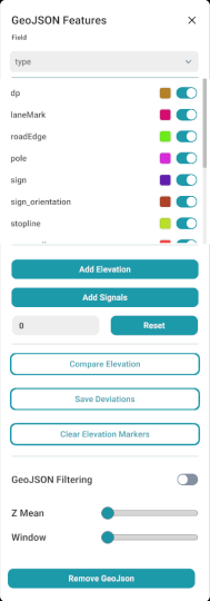
At the top, the Field dropdown chooses which GeoJSON property drives categories (for example type). For each distinct value under that field, the list shows a colour swatch (edit to change how that category is drawn on the canvas) and a visibility toggle so you can show or hide whole categories without removing data.
This matches the property keys and values you chose during import; use it when you want to tune colours or hide clutter while aligning the map.
Add Elevation
Solid buttons support elevation workflows:
- Add Elevation — apply elevation from the GeoJSON or associated processing (behaviour depends on your data and import pipeline).
- Compare Elevation — compare against another elevation source or baseline.
- Save Deviations — store elevation adjustments you have made.
- Clear Elevation Markers — remove elevation markers from the view.
A numeric field with Reset clears or zeroes the associated offset or adjustment (for example after experiments).
Add Signals
Add Signals imports traffic signals from a GeoJSON file and places them on the map. Signal properties are read from the GeoJSON and mapped using a configurable settings file.
Because GeoJSON datasets may use different property names and values, you can customize the signal mapping without modifying the application.
Configuration file
<RepliMap Installation Folder>
└── StreamingAssets
    └── geojson_settings
        └── geojson_signals_config.json
Update geojson_signals_config.json so the property names and values match your GeoJSON dataset. Then use Add Signals to import traffic signals with the configured mapping.
Note
- The file must remain named geojson_signals_config.json. If it is renamed, RepliMap will not read the configuration.
- Before you change the configuration, create a backup of the original geojson_signals_config.json file.
GeoJSON Filtering
Use the GeoJSON filtering master toggle to turn filtering on or off. When enabled, Z Mean and Window sliders adjust how features are filtered—typically refining which geometry is emphasised using vertical (Z) statistics. Exact behaviour depends on your data and version.
GeoJSON customizations
GeoJSON has no universal property schema, so imports often need source-specific field mapping. Out-of-the-box automation may not support elevation or signal generation for every dataset. Contact us to define the right mapping for safe, reliable import.
Validation
Before relying on GeoJSON in production:
- Check for invalid geometries (self-intersections, unclosed rings).
- Ensure attributes you need for automation are present in
properties.
Related
- HERE HD to XODR (H2O) — when GeoJSON is an intermediate or sidecar to OpenDRIVE export.
- GeoJSON to XODR (G2O) — convert road-network GeoJSON into OpenDRIVE (
.xodr). - Sensor data — combining vector reference with sensor-driven refinement.